There is another airspace shape that we have not covered yet in our plugins 'family' to create airspaces: rectangle shape. Airspaces sometimes are defined as 'buffer' zone around line connecting two points or more points. Let's deal with the case that only two waypoints so far because this special case is quite often used as part of other more complex airspaces.
Friday, 31 May 2019
Tuesday, 28 May 2019
Dealing with obstacles data stored in CSV files (1)
Authorities sometimes publishes obstacle data sets called eTOD, which stands from Electronic Terrain and Obstacle Data. Those data sets comes in various formats: csv files, dat files, xml files (AIXM format) or even shapefiles.
This post will start a mini-series which result will be a QGIS plugin to import eTOD data from CSV files into PostGIS database.
This post will start a mini-series which result will be a QGIS plugin to import eTOD data from CSV files into PostGIS database.
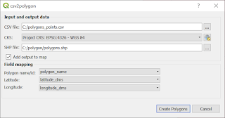
Tuesday, 21 May 2019
QGIS Plugin: csv2polygon
Another plugin that takes data stored in CSV file. This time you can create polygon. It is especially useful, when you have tabular data that describes polygon (e. g. airspace) as pair of latitude an longitude values. The biggest advantage is that you can create many polygons in one run of a plugin.

Saturday, 18 May 2019
AviationLatLonCalculator enhancement: user can choose which CSV field is what
Fields from CSV file have been assigned to its values from CSV header file (e .g. BRNG, DIST) inside the code so far. User has to prepare input file with 'correct' header - otherwise won't be able to perform calculations. And this is a big disadvantage.
Let's assume that we have following data set:

Let's assume that we have following data set:

Sunday, 5 May 2019
Parsing NASR data: NAV file
Let's start with defining the fields that values we want to extract from data file. Notice that this for the time being, only some basic data we want to extract so, dictionary contains only one 'subdictionary' NAV1. For more information refer to file description.
 navaid_fields = {'NAV1': {'NAVAID_FAC_TYPE': (20, 9),
                          'NAVAID_NAME': (30, 43),
                          'NAVAID_LAT': (14, 372),
                          'NAVAID_LON': (14, 397),
                          'MAG_VAR': (5, 480),
                          'MAG_VAR_EPOCH_YEAR': (4, 485),
                          'CHANNEL': (4, 530),
                          'FREQUENCY': (6, 534)}
                 }
Subscribe to:
Comments (Atom)